
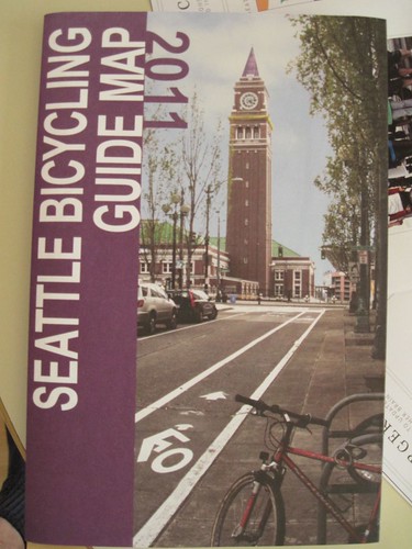
Just picked up a copy of the 2011 Seattle Bicycling Guide Map, and couldn’t help noticing that the Central District is not on the map anywhere.
A great big CAPITOL HILL identifier runs from 15th to MLK, roughly centered on John, but clearly crossing Madison.
They found room for a little sign saying MADRONA but apparently not for one to identify the Central Area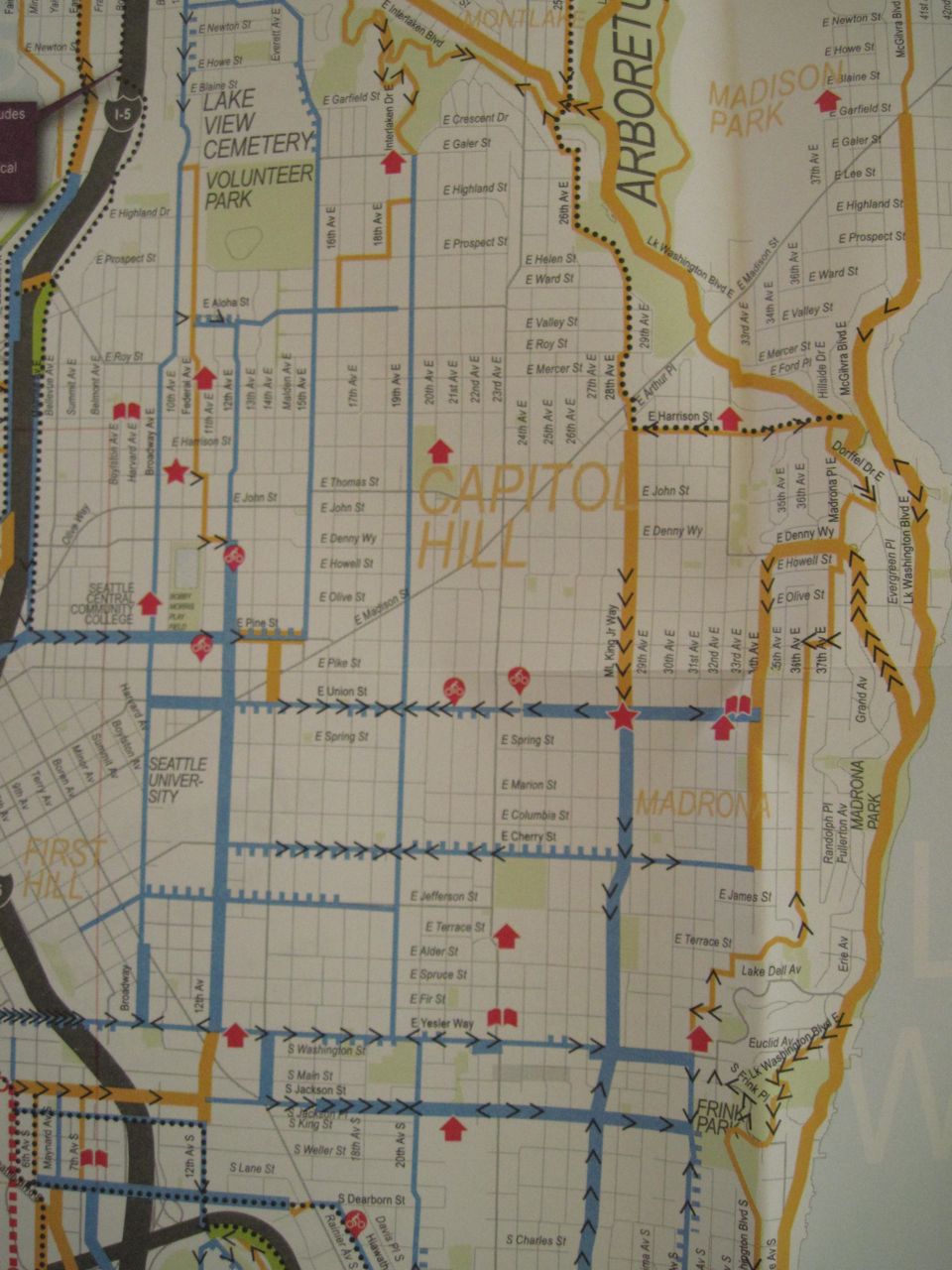
Well, isn’t cycling stuffwhitepeoplelike.com?
As they try and price their customers’ houses in the Central District higher, who really cares if they blur the line and report things as being on Capitol Hill. Adds a small fraction of a percent to the price, I’m sure.
Who would want to bike through a containment zone of criminals.
i can’t believe i’m writing this, but for once i agree with “eyes”.
Thanks Andrew, this is funny/sad. Aren’t we paying for these maps?
In the 90s I had an apartment building just south of Madison. Of course I advertised it as “Capitol Hill.” Most people would not read an ad for “Central District.”
I mounted a sawed off on my down tube. I may not be safer but I fit in.
I also converted my headlamp into a blunt lighter.
The webpage for the map has a comment email listed. I just sent the following. Others may want to respond too, although I think I got the point across:
Hello,
As a cyclist, I was thrilled to see the new and improved Seattle Bike map just released. However, I was saddened to see that the map does not acknowledge the existence of the Central District. This neighborhood – roughly the area east of 12th, south of Madison, west of 32nd or so, and north of I-90 or Rainier, including various sub-neighborhoods like Squire Park and Cherry Hill – is the historical and cultural heart of Seattle’s African-American community. With upwards of 20,000 residents, it is nearly as populous as its neighbor, Capitol Hill; and far more populous than its neighbors Madison Park, Madrona and Leschi put together, all of which you do label. The Central District may not be a major biking destination in its own right (except for the thousand or more bikers who live here), but it certainly sees a large number of people biking through.
As a demographer, I’m well aware that a map cannot include every detail of the area it covers – often including all of a city’s neighborhoods – but given how populous this area is, its exclusion is surprising. In fact, your label for Capitol Hill extends far into the Central District, when it could easily have fit inside the Capitol Hill neighborhood on your map. This suggests that the mapmakers don’t even realize our neighborhood exists, and has its own long-standing and unique identity, but rather see it as simply part of Capitol Hill. This is not correct, as residents and local agencies alike will attest to.
I very much hope to see the Central District appear on the next edition of the map!
Yours,
Steven Goodreau
UW Center for Studies in Demography and Ecology
Central District resident
P.S. You can learn more about the Central District at:
http://www.centraldistrictnews.com
http://en.wikipedia.org/wiki/Central_District,_Seattle
http://www.historylink.org/index.cfm?DisplayPage=output.cfm&
I love to see this kind of pro-activity! It is what community is all about!!
Thanks. Much more eloquent than my E-mail to them.
Andrew
When I moved to 24th and E Pike area 21 years ago, I was told to say I lived in West Madrona!
Indeed. CD should be marked in red and pointed out as a clear threat to safety. Bicyclists have been mugged and beaten, robbed. They should be warned to avoid the area or pass through very quickly.
When we bought our first house on Mercer between 23rd and 24th Ave E in 1988 or so, no one had a name for the neighborhood. I think it is East Capitol Hill or Miller Park now. Essentially any place that black people were allowed to buy housing under the redlining rules after the war was considered “Central District” As demographics changed, there was (and is) some cognitive dissonance. Capitol Hill is growing because it is a known, desirable brand name.
From the CD, African Americans are moving upscale to the suburbs, and downscale to Skyway etc., where poor people pay the commuting “tax”. Whites and other ethnic groups with capital are moving in to enjoy the in-city benefits, and applying sweat equity to dilapidated buildings. There is no right and wrong here – these kinds of changes are normal. Before redlining there were other ethnic communities here, and in the future there will be others still.
The Central District has much to be proud of, and certainly deserves a place on a bike map!
Thanks for doing that!
Methinks you’re reading waaaaay too much into this. It was a government design project. The person who put the map together probably had half a day to slap it together. But at least they bothered to make a biking map for the citizens. Let’s just be grateful for small wins, right.
The labels look completely random, not neighborhoods or destinations, but just whatever they felt like making big to add visual interest. BOEING FIELD is giant, like the parks, as if it’s some type of biking point of interest. It’s simply a quick, not-too-well-thought-out map. I’m sure no one sat down and thought “the CD sucks, let’s not put it on the map”. International District and a few other neighborhoods aren’t on there either.
I totally agree that it was inadvertent, not purposeful. I totally agree that in and of itself it’s not big deal. I don’t think anyone said “The CD sucks, let’s not out it on the map.” But I do believe – having worked as a demographer for a long time – that the Central District just happens to get inadvertently left off of maps and documents (public and private) far more often than do other neighborhoods of similar size. The same is true in most other US city with just one or two historically Black neighborhoods. I’m just trying to do my small part to try to stem that tide.
Oh, one last small point. I can see the argument that we should expect to see the CD left off of tourist materials and things like that fairly consistently, and perhaps even bike maps, since it’s not really a bike destination. But the last two times before this that I saw the CD being inadvertently left off of materials both had to do with public transit maps. You definitely can’t say that transit isn’t important to the CD! It really is a broader pattern.
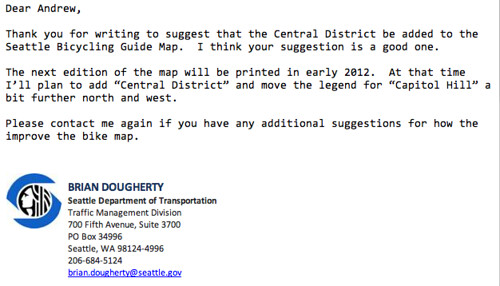
And here’s the reply:
Dear Steven,
Thank you for writing to suggest that the Central District be added to the Seattle Bicycling Guide Map. I think your suggestion is a good one.
The next edition of the map will be printed in early 2012. At that time I’ll plan to add “Central District” and move the legend for “Capitol Hill” a bit further north.
Please contact me again if you have any additional suggestions for how the improve the bike map.
BRIAN DOUGHERTY
Seattle Department of Transportation
Traffic Management Division
700 Fifth Avenue, Suite 3700
PO Box 34996
Seattle, WA 98124-4996
Institutional racism. Their not aware that they are doing it, not intentional just an automatic reaction/action. Of course we are off the maps and we are not a destination, if we were they would not be able to maintain this area as a social service dumping ground and a containment area for criminals. Do we have the street life and business districts like Fremont, Wallingford, the U district, Queen Ann, West Seattle etc. etc. Talk is cheap, let’s see what is really done next year. Perhaps they should reprint the maps and recall the ones sent out? Ohhh too much $$$, can’t spend money for that area!
thnx
Down my street to avoid the crazy traffic on mlk. Happy to have them riding past. Thanks for proactively reminding our civil servants that this is the central district, not whatever real estate people want to call it any given month!
“This neighborhood – roughly the area east of 12th, south of Madison, west of 32nd or so….”
The City’s neighborhood signs for Madrona and Leschi (on Union and Cherry, for example) use MLK as a dividing line between those neighborhoods and the CD. Certainly this is neither here nor there as relates to leaving the CD off the map; however, I’ve never thought of the CD stretching all the way over to 32nd. And, any time I’ve heard it referred to in conversation, people always seem to use MLK as the dividing line. Just an observation, FWIW.
He should be grateful, cyclists = gentrification.
Thanks for the head’s up, although the response I got for asking about Rainier Valley was far less accommodating. Apparently the only neighborhoods south of I-90 worthy of identifying are Beacon Hill, Columbia City and Rainier Beach.
I sent Brian Dougherty this email. Another suggestion for the bike map.
I saw on centraldistrictnews.com that you are going to change the Seattle bike map next year to include the Central District. That’s a great idea. Here’s another take Yesler Way off the map as a bike route. Have you ever ridden up Yesler Way? You should try it, it’s steep as fuck and I see people walking their bikes up that hill all the time. Jackson Ave is only a couple blocks away and goes under I-5 thus reducing the tremendous burden of biking over I-5. I see it is labeled as the steepest bike route on the map but I think people would fare better going the 4 extra blocks and take Jackson.
its not the agents that do this. Its uually the sellers wanting it in the maketing.
Do not embarres the neighborhood by wrint ti the city JR, Bkes go down hill as well as up, but you obviously have a limited mind.