Our land of lovely hills becomes a lot less appealing when the snow and ice hits. The wet streets will freeze overnight and may not thaw out again for several days.
Your best bet is going to be to keep the car safely parked and plan your trips via foot or bus. But if you’re absolutely forced to drive, we’ve assembled a map that shows where the most severe slopes are. It’s just like a ski map: Greens are the most gentle slopes (but not necessarily recommended!), blues are steeper, and blacks should be considered mega-deadly and safe only for experienced Yettis.
You can see that there’s really no good way to get downtown, or even to Capitol Hill in most cases. Luckily there’s some less treacherous paths to the groceries you get hungry or need to refresh the beer supply.
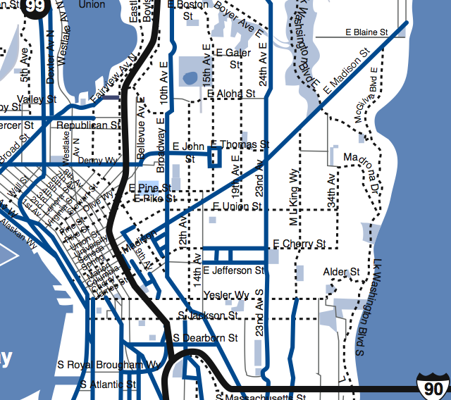
Here’s a DOT map that shows which routes get priority for the snow plows and sanders:
And for an example of how bad it gets, here’s a video I shot at 27th & Yesler during a snow about a year ago:
You can see in the video even parked cars are at risk of getting dented by someone else slip-sliding down a hill, so you’d be smart to not leave your vehicle parked along any arterials.
Seen a particularly slick street? Leave a comment below. And make sure to share your snow photos and videos by uploading them here.


Proves that this is not just doom and gloom this websites values continue to improve my life in Madison valley.
This entire series of winter warnings gives me just that much respect for your pursuit, of well, what ever that is
Great map great info Thank you, Scott.
Happy Holidays
to all my CD People.
Synodone
Thanks for giving me a sledding map.
May I tell you how great this map is? I just pulled this back up from last week to plot my tentative trip to Sea-Tac tomorrow morning at 6:00 am. Lookout for crazy lady doing switch-backs down the hill!