Although Seattle has big plans for a larger network of streetcars in the city, only one of the routes has definite funding. Last November’s voter-approved expansion of Sound Transit included funds for the capital and operational costs of a streetcar route to connect the International District and Capitol Hill light rail stations with the major employers and residents around First Hill.
And while funding is available, one crucial detail has yet to be decided: the exact route. Some key interests on First Hill have been lobbying the city for a westerly course that curves around via Boren & E. Madison. But for the last several months a group of neighbors, non-profits, institutions, and bloggers (i.e. me) have been discussing the various options and have coalesced around the idea that the biggest long-term opportunity for the streetcar is on the east side of First Hill. The thinking is that the east side has a lot of jobs, residents, and potential for future growth and development, but very few existing transit options. In contrast, the west side of First Hill has a lot of quick bus connections to and from downtown and is largely developed, limiting the potential for a streetcar to attract additional future ridership or new pedestrian-oriented development.
The group’s conceptual map shows two new options: 12th Ave, and a 12th/Broadway loop.
The 12th Ave route directly serves the front of Seattle University and provides access to major employers such as Swedish Cherry Hill, Swedish First Hill, and the King County Juvenile Justice center. Plus it could be the catalyst for a new generation of pedestrian-oriented development along the southern portion of 12th:
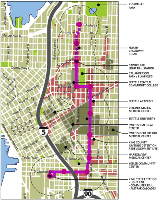
The loop route attempts to expand the total reach of the streetcar by serving two major north/south streets, putting more residents and employees within walking distance of a streetcar stop, and thus a short ride away from a light rail connection:

In a letter to Mayor Nickels last month, Seattle University President Stephen Sundborg asked that a 12th Ave route be studied as an option for the new streetcar. Another interested party is the non-profit Capitol Hill Housing group which is planning several low-income apartment projects along 12th.
At a First Hill community meeting last night, Seattle Department of Transportation project manager Ethan Melone said that the next big step in the project is to finalize an agreement between Sound Transit, who is funding the project, and the city, which will build and operate the streetcar. They hope to get that final agreement in June, at which point the city and its consultants will start to analyze the details of the different alignment options.
Mr. Melone says that the biggest factors in the alignment choice are:
- Ability to maintain 10-minute service during peak hours without requiring more than 3 or 4 trolley vehicles (shorter, more direct routes have the advantage)
- Construction cost (utility conflicts are a big factor)
- Ridership
- Terrain (streetcars have difficulty with steep slopes)
The city will hold a round of public meetings later in the summer to collect citizen comments on the project. Once a final alignment is chosen, the city hopes to start construction as soon as 2010, with a start of service in 2012. That schedule is dependent on an accelerated delivery of funding from Sound Transit.
Some nice pictures from the U of W archives of Seattle’s Electric Street Railway from the last time we had one are at http://tinyurl.com/dd6975 .
I think 12th is a better option, although I’m not opposed to the loop around 12th and Broadway. The Southeastern corner would only be a few blocks from the proposed Goodwill/Target redevelopment (sorry Bill), although this really needs (near) future expansion up Jackson all the way to Frink Park. That would improve the Promenade, the existing development along Jackson between 23rd and Rainier, and provide easy connections to Light Rail at the International District and Cap Hill stations.
If we could get some kind of line to Ballard/Freemont and West Seattle, the entire city (except Madison Park, but they can drive their Bimmers) would finally be connected, or have planned connections, via rail. Sweet.
Regardless of what happens on that site – and my hope would be for something more like what InterIm is proposing than the current big-box model – enhanced transit connectivity along Jackson makes a lot of sense.
Remember, though, as Scott points out, that we only have funding for one piece of this thing through Sound Transit. *IF* there is money left over, we can go to bat for a Jackson Street extension. But we have to get the first part built first.
Capitol Hill Housing is definitely involved in planning housing developments along 12th. But we are actually more concerned with transportation on 12th as an economic development issue. Our 12th Avenue Initiative is trying to address some of the challenges along the corridor (vacant land, no north/south transit service, parking lots on a main arterial, business district issues) to better the experience for the pedestrian and for businesses on 12th. The City’s own literature is pretty straightforward about why we should be building streetcars and it is not just for transit options. In fact, bus service provides better transit options per dollar spent. Cities build streetcars for economic development reasons – to transform areas that have not experienced revitalization, such as 12th avenue, particularly the southern end of 12th between Little Saigon and Cherry to the north.
the momentum and assumptions seem to be that the line will run up and down Broadway. If folks think 12th should be in the mix, then it’s worth contacting people on the Council, especially Jan Drago [email protected] and Ethan Melone at SDOT [email protected]
From my perspective the original light rail station was to serve the CD and First Hill. I don’t know how it turned into a ride for Harborview employees when Harborview was nowhere near the original station and is already really close to the ID.
I see a streetcar routing on 12th as a great opportunity to connect the Central Area with Capital Hill on a route that has no transit now. We all know how difficult it is to get to Capital Hill from parts of the CD and how psychologically disconnected it seems to be.
As Kate noted above, a streetcar also serves commercial life, which is coming along on 12th, whereas that stretch of Broadway is pretty much a done deal with a lot of housing, not commercial.
Obviously, I like 12th as the routing, but the loop would work out fine. The loop would mean less track and construction impact on each street, leaving more room for the bike lanes, yes?
The now unused waterfront streetcar tracks end exactly where this line ends at 5th and Jackson. It would be a no-brainer to connect the lines and make Cap Hill connect all the way down the waterfront, past the Pike Place Market, to the sculpture garden and Belltown. The waterfront tracks are only idle because there is no political will to relocate the trolley barn after the sculpture park displaced it. The First Hill streetcar would need a barn. It would be an easy way to bring some existing tracks back to life. We can retire the quaint tourist trolleys and run the nice modern streetcars down the entire line.
@centralcinema
there are actually 5 streetcar lines in the works. a map can be found here: >http://www.seattlestreetcar.org/future.asp
and one of them is the waterfront that will turn and come up through the ID to connect with the First Hill Cap Hill line.
the really really important thing to note is that this is likely to be the only “free” streetcar, not paid for by property owners, like the SLUT (south lake union trolley) was. this will be funded from prop 1 that was passed last fall.
My hope is for construction to begin on the Goodwill site now. We need the stores proposed not shallow reactionary nimby obstruction.
I know Broadway is busy and for anyone that drives it, it’s a pain, but I think that’s why I like the idea of a streetcar running through it. It’d be a destination again and would be so easy for those getting to the hospitals as well as going to the schools. The loop is nice, but if I had to vote, I’d pick Broadway option.
Streetcars have two purposes. Economic development and as a transit option. It seems there are two values competing here. The First Hill medical community would like connections that serve their many employees and visitors. And 12th offers far more potential for community redevelopment and connecting a neighborhood with relatively little bus service for a dense urban setting.
I think the loop accomplishes both very well. This is a relatively short streetcar line and with frequent trains people would be able to access a far wider area without much added time.
These are great visual proposals from the neighborhood. They deserve praise for starting a real debate on the alignment.
No reason to retire the old cars unless they can’t handle the power on the new lines. Look what SF’s done by reusing the old PCC cars – tremendous tourism asset. Just make sure to build a big enough barn!
“Modern” streetcars may be “nice” because they’re low-floor and accessible, but they have pretty much zero aesthetic appeal. They’re blah – functional but blah. Having said that, lots of people will ride them who won’t ride a bus, so they’re worth doing.
We have to keep an eye on those headways. Ten minutes really makes a difference versus fifteen, as all of us who ride Metro can certainly attest.
A couple of things to consider, I think: Sound Transit sees the streetcar as a means of transportation from/to two light rail stations — the one in the International District and the one at Broadway and John. Currently there are a handful of express bus routes that, during morning and evening commute times, go from the vicinity of the future light rail stations downtown directly to Harborview, Swedish First Hill, and Virginia Mason. Is there a strong argument to spend streetcar dollars to duplicate or replace a transit service that currently exists and is, no doubt, a faster means of transportation than a streetcar? Why not put the streetcar route on 12th where it can act as a catalyst for new residential and retail development, and provide a transit route where none exists?
I agree. 12th Avenue would make the most sense and would provide a new, not duplicate service, and the Broadway and 15th Avenue areas are both very accessible from 12th Avenue, but I would support the loop if the choice is between that the Broadway option.
All would provide additional transfer points for some of the CD buses, but none can be really counted as direct route for most of the CD.
the Dearborn Street project had asked for up to ten years to start; Council gave them 5. Rumor is they may come back and ask for seven during the street vacation phase. That is on hold waiting for the developer to complete more work (not so incredibly DPD approved the project without approvals from SPU).
The developer still needs further design development necessary to get a building permit – that work won’t start until they get a loan. With the commercial paper market the way it is, and the difficulty with malls and big box retailers, you won’t see that for a while. Point being, don’t hold your breath for the mall.
Now is the time to consider other options. Watch CDN for a post on a proposal from CARD (Community Alliance for Responsible Development)…
Built the loop – it will serve two corridors, and minimize the footprint. There is a fine loop route I remember riding in Melbourne – much larger line but function is great.
Check out how the Portland Streetcar operates. http://www.portlandstreetcar.org/
Loop and couplet design seems to be the best in terms of ridership and connecting people to where they need to be. I was unaware of so much redevelopment going on on 12th Av
enue that it really does make the most sense to build on 12th and return on Broadway. Boren is not an issue for the streetcar. The hill itself is only 6.82% and most modern streetcars are capable of 8 to 9%.
Grades for the United Streetcar (New Streetcar built in Portland, Oregon) has already been approached by the City of Seattle to provide the new vehicles for future lines. I’ll be taking a tour the streetcar itself on May 9th.
My biggest concern has been the maze of trolley bus wire on 12th Avenue.
It would be nice if we could get working on the restoration of the Waterfront Streetcar but there is no will by any government official to return the streetcars back onto the waterfront. If I was in any position, especially with the future of many other streetcar routes, this presents a golden opportunity to have a second but large and main operations and maintenance facility for the streetcars, modern and vintage fleet. Now would be a good time to get Seattle to lobby for the return of the WF streetcar, even if it is just for the Spring and Summer months.
Ethan Melone in an email to Tracy Reed at Sound Transit stated that the Inekon Trio streetcar that operates on the South Lake Union route is capable of a maximum gradient of 9.0 percent. In an email to me, Patrick Hastings, Chief Surveyor at Seattle Public Utilities wrote that the gradient on the steepest section of Boren in the Yesler Terrace area was 8.7 percent. That’s so close to the maximum capability of the streetcar that on rainy days the cars would surely go “slip, slidin’ away”. A 10 percent safety margin of 8.1 percent maximum for the the streetcar would be best. That eliminates Boren from a posssible route. At the original public meeting the city council Transportation Subcommittee held on the First Hill proposal, all who spoke on possible routes suggested using E 12th Ave. instead of Boren. The best connection between E 12th and Broadway appears to be Union. If you walk the E 12th Ave and the Boren routes, you’ll see that E 12th has great redevelopment potential and that the Boren route is too steep to stop a streetcar or has already been developed. I hope the city chooses the E 12th Ave route for construction and runs a trolleybus along the Boren route to keep Sound Transit happy.
The streetcar lines along the waterfront will be gone as soon as the Viaduct/Seawall project gets underway. The whole Alaskan Way corridor, from buildings to water, is getting dug up and rebuilt because the soil is unstable, and could take out the seawall in an earthquake.
I like the 12th ave/Pine/Broadway option better than the loop. The section of Broadway south of Pine is dominated by Swedish Hospital on one side, and the back of Seattle U on the other. Seems a shame to run a streetcar line down such a large stretch of street, when there’s really only one destination on it. Seattle U would be better served from the 12th Ave side, and there’s also a lot of mixed residential/commercial stuff along 12th there. Better to keep both directions on 12th. Residents in the blocks east of 12th will have better access; on Broadway it’s cut off from residents in the east by the school, and from residents in the west by Swedish.
I see that the loop route has the section on Broadway north of E John drawn in a dashed line, implying it might not be built. To me, it seems like the whole corridor from Pine to Aloha really needs the service; there’s a lot of foot traffic in that neighborhood, and some huge mixed-use developments at the far north of the line. We should support future development in that area by linking it to the rest of the city, it seems a bit cut off now.
One thing no one is talking about is the zoning laws that are in place between these two areas. If the car is run at the top of first hill (broadway) then infill development can really explode to the west of broadway. If you walk around that neighborhood it is dominated by parking lots and a lot of one story buildings that could be redeveloped. That area is zoned for much higher density than 12th avenue. While it may be nice to have new development along 12th the zoning does not allow for higher density and taller buildings. That could change in the future and should if they chose to build the line down 12th.
It seems that there are good arguments for both ares. Why not compromise and run it down both in the loop. Then both areas are served.
It would be a First Hill Streetcar that doesn’t serve First Hill.
The purpose of the FH streetcar is not to get residents to and from downtown but to connect First Hill (where the Link light rail station was going to be) to the Link light rail system. Secondary benefit is to connect FH residents, especially YT residents, to the shopping opportunities (multiple grocery and drug stores) on Broadway. Please let’s not ignore this market and these riders.