
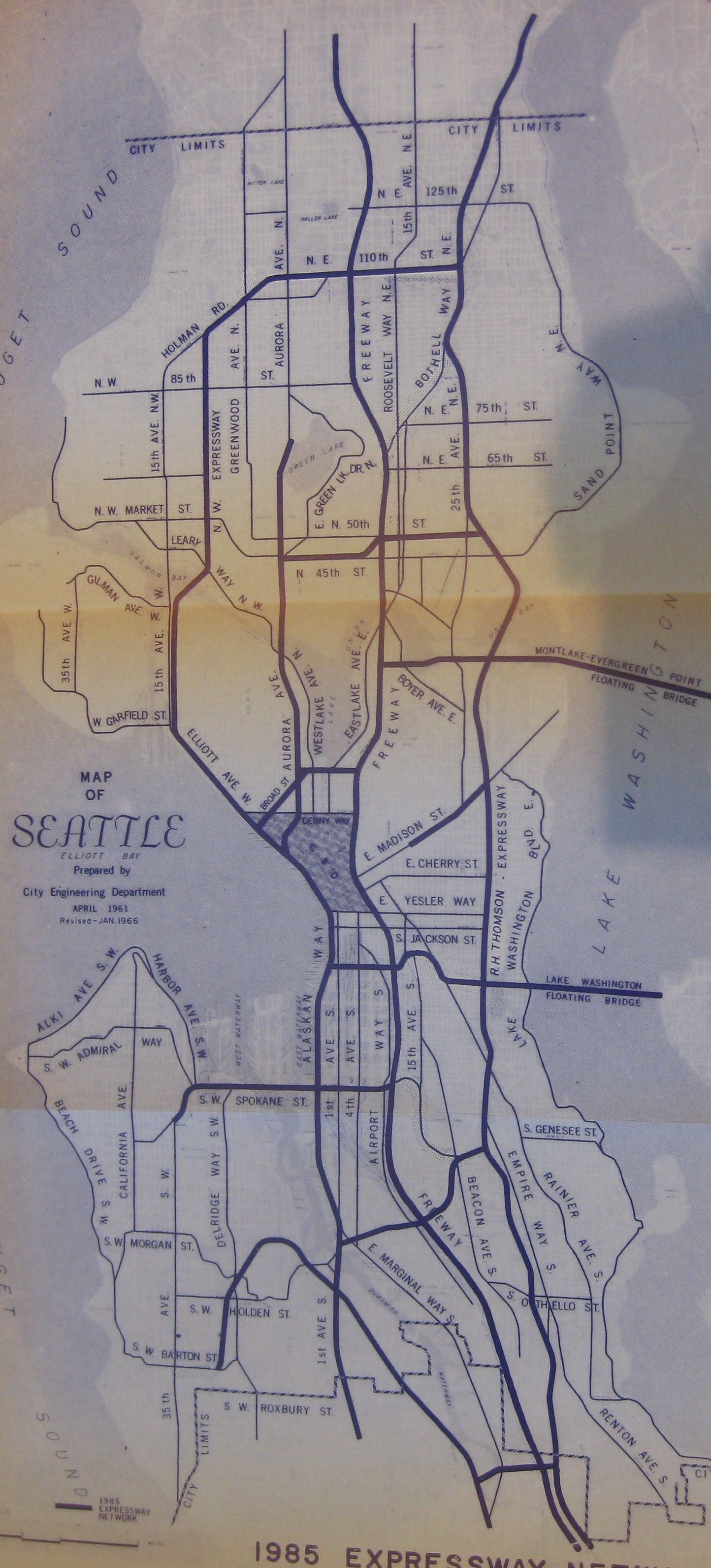
Think back to the sixties, at the height of the national freeway building craze. I-5 is under construction, slicing its way through the center of Seattle and destroying tens of thousands of homes and businesses that stood in the way. But even back then planners could see that I-5 wouldn’t provide enough capacity to zip people through the city, so state and city officials created a freeway master plan that would have placed additional expressways on both sides of I-5, running north and south along the length of Seattle. Additional east/west freeways would tie them together into a massive grid with controlled-access highways spaced about a mile apart in every direction.
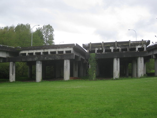
The first big piece of that plan was the R.H. Thomson Expressway, which was designed to relieve I-5 via a route through the eastern half of the city. Connecting to I-5 near the south end of Boeing Field, it would head north with major connections to I-90 and the 520 bridge before continuing northwards to Lake City Way and the north end of Lake Washington.
The highway would have roughly followed the route of Empire Way (renamed Martin Luther King Jr. Way in 1983), cutting a trench through the middle of the Central District. It would have occupied the block between 27th Ave and Empire Way along its entire length, destroying thousands of homes. And with freeway crossings only at the intersections with major arterials such as Cherry, Union, Yesler, and Jackson, it would have created a wall of traffic and concrete between the neighborhood and Lake Washington.
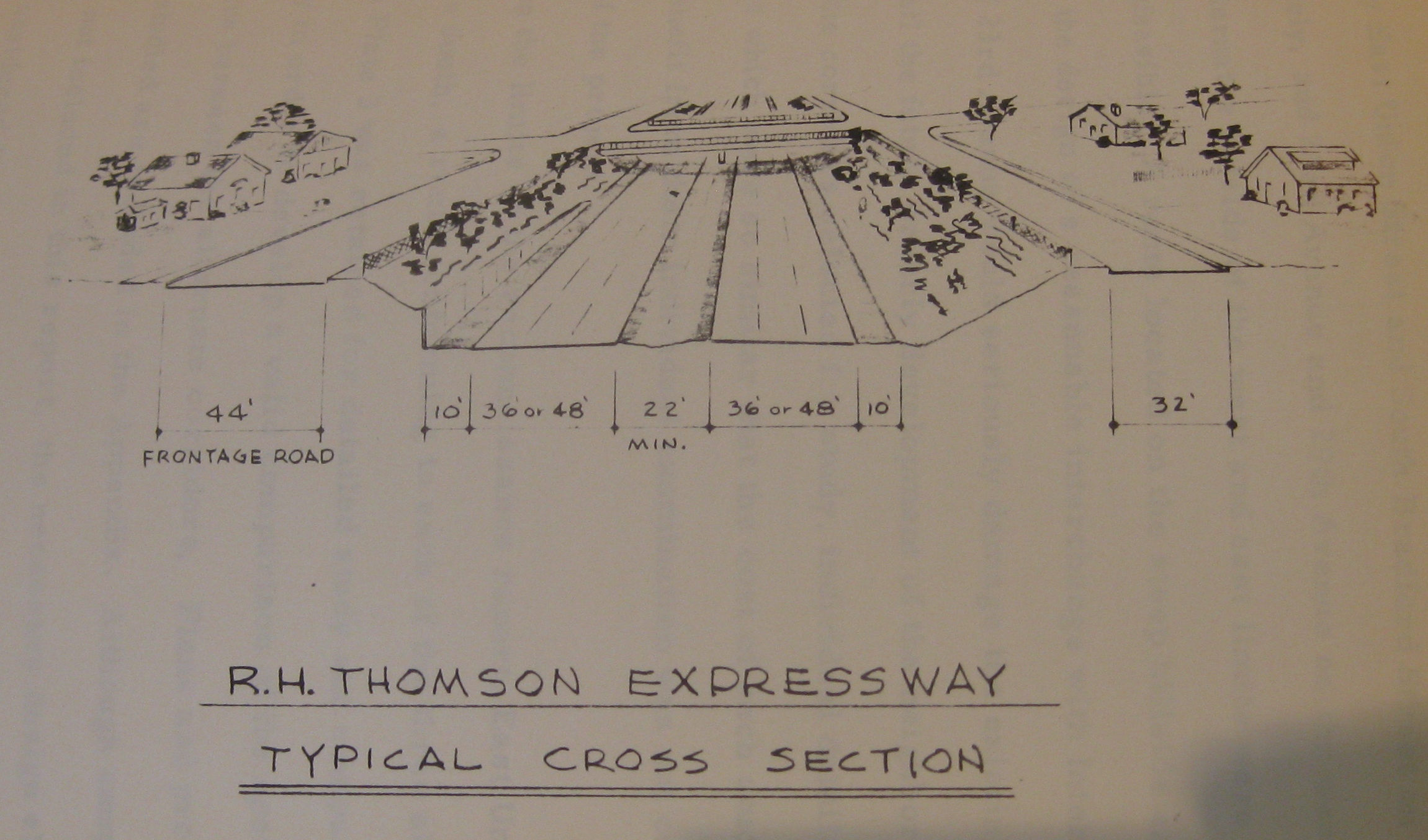
Plans provided for six highway lanes and additional collector streets along each side, with an estimated traffic volume of 70,000 vehicles per day by 1985. It gave neighborhood residents access to the freeway via on and off-ramps at Madison, Cherry, and Jackson streets.
But thankfully it failed. Residents from Montlake and the Central District and supporters of the Washington Park Arboretum organized Citizens Against R. H. Thomson (CARHT) and flooded city council meetings with arguments against the project. A group of homeowners in Montlake also filed a series of lawsuits over the route through their neighborhood and its effect on private property. The project was delayed, and eventually elected officials felt the pressure and placed the project on a special election in February of 1972, where it was voted down and killed once and for all.
Here’s a Google Map of the freeway’s route:
View Thompson Expressway in a larger map
Thanks for the interesting history lesson, Scott. This would have been a block from my house! I’d always wondered about those “ramps to nowhere” on 520.
I’d love to learn more about the construction of the I-90 tunnel, which did (I’ve heard) destroy neighborhoods. When did that happen? What were the politics at the time? Am I too cynical for thinking that the Thomson Highway was stopped but the I-90 tunnel went through because Montlake residents had more clout than CD/Judkins Park residents?
One fascinating aspect of this tale is the legacy of the homes that used to be East of 26th Ave and north of E Lynn Street. This is a part of the Arboretum (NorthEast of the “Tot Lot”) where there is still a nice concrete “street” (with a curb!) that connects to the brick arch walkway (actually a sewer) to the main part of the Arboretum. The posted PDF document on pages 30, 42-44 tells about all the back-handed shenanigans that took place in buying up these properties (and then allowing them to decay) in anticipation of the RH Thompson Freeway.
citizens sometimes have to be smart.
I have a book that was written about the I-90 and RH Thompson Freeway projects covering over 30 years of citizen law suits, fighting the good fight for their neighborhoods.
I chaired the I-90 Citizens Development Advisory Committee for 12 years. Scott if you want interview me and others about the history (newspaper clippings and all) contact me.
Did you know about the proposed freeway ramps at 23rd and I-90 that the Judkins/Rejects Community Council fought and won? It would have destroyed Judkins Park, destroyed many houses and provide a “wall” keeping minorities from using the new I-90 lid park. The longest serving state legislator (per the Guinness Book of Records) lost his job over it when the PI found out he would benefit from the ramps.
And many, many more……..
falcon,
Can you provide me with the name of the book you mention? I would love to check it out at the library. It sounds interesting.
Thanks!
Thank God that freeway wasn’t built, but unfortunately the Seattle citizens of that era weren’t smart, just obstructionist.
These same visionary Seattleites voted down Forward Thrust mass transit and the subway went to Atlanta instead, with 75% paid for by the Federal government.
Those citizens thought that by stopping this freeway, Forward Thrust, and other things, they could keep Seattle a small town and not need big-city infrastructure. Didn’t quite work out.
Where can I find this PDF document?
That’s all well and good that we’re here patting ourselves on the back for NOT building this expressway, but sadly, today the traffic problems are far worse. The problem never got resolved, I5 is completely over-capacitated, and instead four north-south corridors we have only one. That’s not a solution. The city still needs to address the problem, they haven’t and refuse to, and here we are.
Lest you think jammed traffic IS a solution, my family got a reality check last month when a family member needed to be rushed to the UWMC on a Saturday evening from Edmonds. Problem was southbound I5 was a mess to 175th, so instead of the ambulence getting there in minutes, it took over an hour.
We have no solution, and yes the neighborhoods were saved, but we HAVE NO SOLUTION. Ignoring the problem is not a solution, and yet that’s what the City of Seattle has done for the past 40 years!
A: There is no evidence that building the expressway would lead to less traffic (in fact, basically every study that exists on the subject suggests exactly otherwise).
B: This is our neighborhood. Living here and having neighbors is far more important and valuable than simply providing a space for people drive their cars through it without having to stop (though, as we all know, it would be stop-and-go anyway, so it wouldn’t even matter).
C: Sorry I-5 sucks. But it’s rather insulting you think my neighbors’ houses would be better suited as a polluting, loud freeway. Come hang out at Powell Barnett Park some day and I think you’ll see how great the neighborhood is (and what a shame it would have been to pave over it).
D: Last I checked, there were two major north-south freeway corridors. Didn’t we just invest $4 billion into some tunnel thing?
E: Sorry about your family member. With better HOV rules on I-5, perhaps that problem could be helped?
Pingback: Seattle's R. H. Thomson Expressway | Grumpymonk :: 7 Shots