
The city is about to clear the way for a slightly-later-than-planned April start of construction on the First Hill Streetcar connecting Pioneer Square with Capitol Hill via Bailey Gatzert Elementary and Yesler Terrace. Planners hope an April start will get the project on track for an early 2014 start of service.
The first of two construction open houses is Tuesday from 5 – 8 p.m. at Union Station’s Ruth Fisher Boardroom (401 S Jackson Street). The second open house will be March 7 from 4 – 7 p.m. in the Broadway Room of the Silver Cloud Hotel (1100 Broadway).
Design work is getting to the final stages, so here’s a look at plans for the neighborhood:
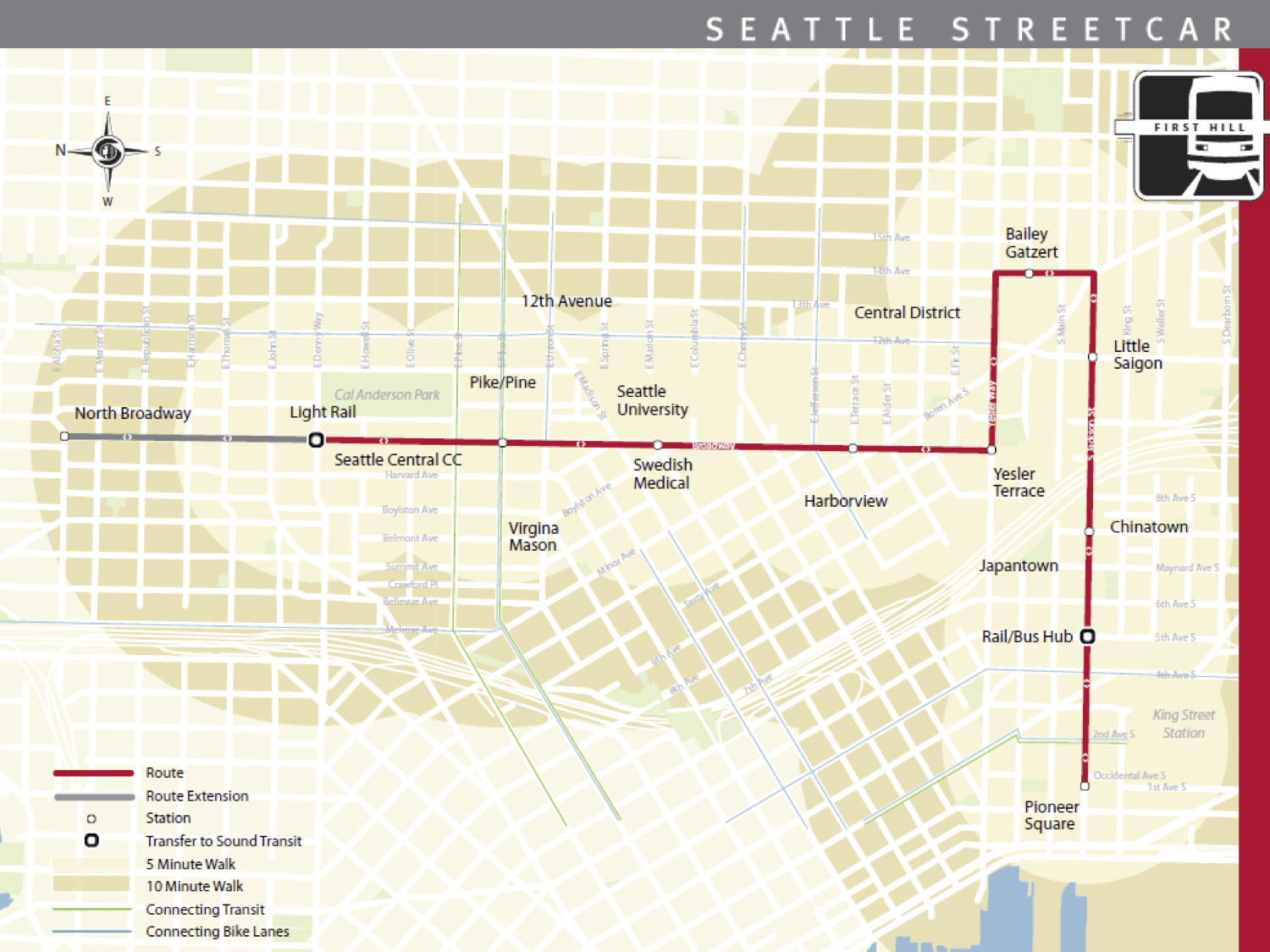
Once completed, large sections of Jackson Place and Squire Park will be within a ten-minute walk of a streetcar stop. The route will run on Yesler Way between 14th Ave and Broadway, then on 14th between Yesler and Jackson, where it heads west to Pioneer Square. The roadways getting the streetcar will be completely reconstructed and redesigned.
Here’s a video flyover of the Yesler to Jackson segment (from August, so some details may have changed):
The intersection of Broadway and Yesler in front of the Yesler Community Center is going to get a complete overhaul. A two-way bikeway on Broadway ends, turning into bike lanes on either side of Yesler (as it is today). There will be a stop on Yesler just after the turn, with public art by Claudia Fitch:
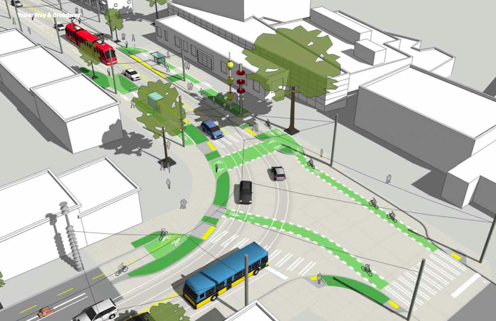
 The Yesler Terrace stop
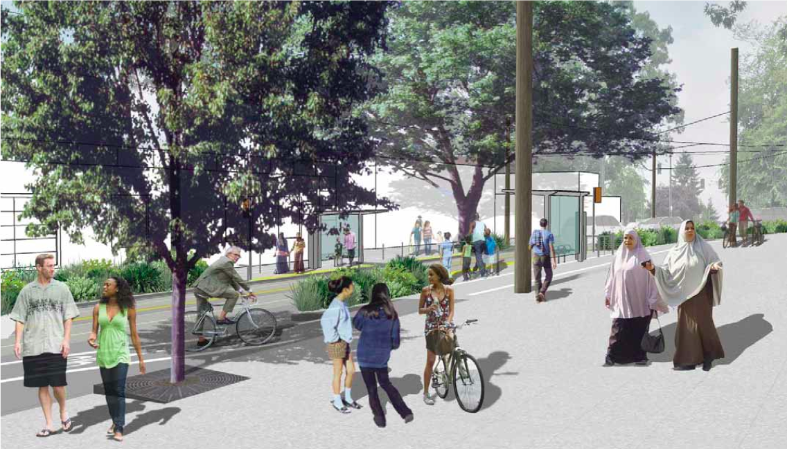
The streetcar then turns on 14th in front of the Urban League building and Bailey Gatzert Elementary. There will be a stop on 14th in front of Bailey Gatzert. Traffic southbound on 14th will be restricted to only the streetcar. People will still be able to drive and bike northbound.
 On 14th Ave, looking northwest towards Bailey Gatzert
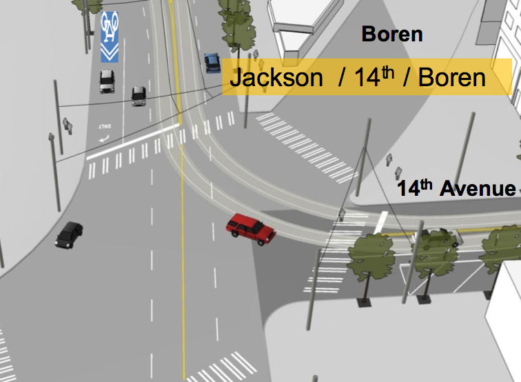
Then the tracks turn onto Jackson at the intersection with Rainier and Boren:
 For more details on the plans, see the Seattle Streetcar website.
The streetcar was designed a couple of years ago, when sharrows were all the rage, and has a 2 way bike lane paralleling it. Things get very awkward (see Yesler Terrace illustration above) when the 2 way bike lane has to return to regular bike lanes on both sides of the street. I’d be very concerned about safety if that stretch of road was at all busy.
QUESTION: sharrows are no longer fashionable, and people are promoting “Greenways”, i,e, using the parallel grid of quiet residential streets for bike travel (something I’ve always done and advocated).
Will this be an orphan 2 way bike lane? Would we be better off swallowing our pride, all going for Greenways and asking if the 2-way-bike-lane $$ could be repurposed for fixing the (typically) awful surfaces on the aforementioned parallel residential streets (or even put towards extending the streetcar?).
Actually, the cycle track on Broadway pays for itself: http://seattlebikeblog.com/2010/09/29/first-hill-streetcar-u
Without it, they would have to do a lot more expensive utility relocation. An example of engineering brilliance.
The cycle track in this plan is definitely not out-of-style. It’s separated from traffic by parked cars, which should make it feel a lot safer than even a regular bike lane (that’s the plan, anyway). I think it’s going to be successful at getting people who would not typically bike around the neighborhood to give it a shot on the new Broadway.
Sharrows, on the other hand, are the type of facility they plan for the Jackson corridor (I wrote more about that here: http://seattlebikeblog.com/2012/02/28/first-hill-streetcar-a ). They basically involve telling people biking and driving to share a lane on a busy street. Only a certain segment of the population is ever going to feel comfortable doing this, which is why it is going out of style. Examples include sharrows currently on 15th/19th Ave E.
there is nothing fashionable about sharrows – unless you think asphalt and white paint are sexy.
but is seems like there is some confusion regarding sharrows and greenways – so i thought i would put some info out there:
sharrows are only one tool for management of bike traffic. they are typically reserved for down hill on arterials – they shouldn’t be used on roads that exceed 35 mph – and they are the least desirable management tool for both cars and cycles as they require a level of negotiation that a cycle track or even a bike lane do not –
Greenways is a sort of designation given to a roads – sharrows can be a part of a greenway – but so can chicanes, traffic circles, and other traffic calming mechanisms. When a street is designed (or re-designed) to be a greenway – and its put on a map – people from out of town or inner city travelers that dont get on a bike that much know they can use the greenway as a means to transverse through a neighborhood with some car traffic mitigation measures in place. in short: you will probably see a sharrow as a design component of a greenway.
as someone who takes 12th from Jefferson to Pike every damn day – on a bike – I can tell you that I am not alone in looking forward to going on up to Broadway to take the cycletrack where i will less likely to be killed by inept non-urban drivers parallel parking on 12th, Seattle U students (also not usually equipped to drive in urbane conditions, and all the parents dropping of their kids at Seattle Academy).
And hopefully SDOT can learn to actually pave bikeways. Looking out for potholes and thundering along (at 12 mph on cobble) while looking out for car doors is a bitch. Most of our streets are horrible for riding on. We have to travel at such a slow pace that bicycling is less effective than Metro or SPD.
That does look nice. Broadway blows any way. I support the change.
Could someone ask the people who make those illustrations if they have any drawings of cyclists in helmets? I know that the illustration depicts a street about 50 yards from the Harborview ER, but I think it would be nice to model sensible behavior.
good point
Will be interesting to see how many current Metro riders will benefit from that 10-minute walk zone. Depending on final destination, it may well not be worth the walk.
Not to mention the annoyance of Jackson corridor riders having to choose between an island stop for the streetcar and the at-curb stops for Metro. If you’re only trying to get down the hill, how do you decide where to wait?
Getting the choice riders will be a good thing, I suppose, and I do think Broadway will be a far better street when the project is complete. But I can’t help but wonder if this project would have been different if it had been designed by the community and transit planners from the beginning, rather than a throw-in sop for the loss of the First Hill Link station.
Oh yeah, because the center platform means loading on the left, which buses can’t do. I didn’t even think about that.
Yup. Again, it all depends on where you’re going (and, at least on Jackson, how big of a hurry you’re in; maybe you have enough time to wait for the streetcar, or maybe you just need to get up or down the hill ASAP).
Aren’t there fines that can be imposed for this reckless promotion of unsafe acts. These artists must be penalized.
By 2014 I will have moved to the Eastside to avoid the I-90 tolls that will eventually be imposed. Otherwise this street car would be really cool. I would certainly go up to Broadway to drink mor frequently and heavily than now. And to eat. Lot’s of great stuff all along that corridor – 14th mostly, but, close enough. Would be nice if we could have a similar line headed to Columbia City but with no stops between I-90 and CC. Or perhaps run up Beacon and then cut down. Just so long as we avoid stopping at the ungentrified areas. I hate getting on a bus full of criminals and meth mules (#7). Anyhoo. From the Western front of the CD to Broadway is a great street car route. And I can see going down King as well. Only issue on the King corridor is that the Crips control security in that whole area for the various asian prostitution, gambling, and smugling rings. That area is ripe for another Wah Me or worse. I’ll stick to my car for now or avoid it all together. Little Saigon is too dirty to bother with. Anybody heard of a broom down there?
The streetcar will be a nice change from the dirty stinky 3 and 4 busline. I think it is inept to plan bike lanes in busy city streets! Bike lanes should had been planned for sidewalks. Less people on sidewalks and no cars on sidewalks. The drivers AREN’T inept. It is too hard to see bikers, especially on the right side where the BLIND SPOT is!
I can agree that mixing is a bad idea. That is why I promote closing every 10th block or so to through traffic and making these streets Greeways/bikeways with only local access to residents on a particular block. It would make for some very quiet streets for 10% of residents and only a minor uptick for the rest.
Imagine 10th, 20th, and 30th Avenues having virtually no traffic.
bikers are dangerous…… seriously get things straight here. *Drivers* are dangerous. Drivers kill somewhere between 40,000 and 50,000 people each year in the US, they maim and injure MILLIONS more (around 2.5 million per year). Cyclists rarely have fatal accidents that don’t involve being hit by a car…. cyclists *rarely* kill others (like maybe once every 10-20 years *world wide*) Cyclists are NOT the problem…. Inept, yes inept and inattentive drivers and weak penalties for killing with a car are.
Not only dedicated green/bike lanes, but bike stations similar to what is currently used in part of Europe where you can rent a bike by the hour and return it to a station. I think this would benefit a ton of people.
Clearly we have more streets than we can afford to maintain. More streets than we need. Every single property in the city has given something like 2500+ square feet to right of way. 30 feet in front and 15 feet in back for the alley. So there is a huge amount of space and right of way available for anything we want. Very simple phsyically to do something. The only things is we have to stick it to somebody. Local access only to cars on every tenth block and improvements to enhance bicycling on those streets could be accomplished with little cost or pain. Today Seattle is kind of a toilet city. Lot’s of potential but we need some plunging and cleaning. Perhaps over time become a more sophisticated toilet like Portland with the bidet and hot air dryer. Perhaps we could even add a Korean scrub.
As someone who works in the design industry, I personally find most of the renderings atrocious. Blah. Characters in these types of drawings are usually pulled from stock sets of people and silhouettes used by architects and planners in all sorts of plans like this. Funny that the stock images don’t include helmets.