
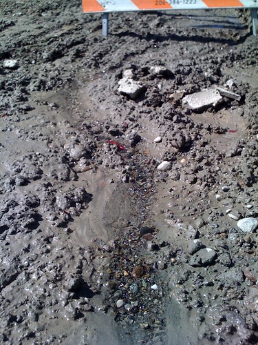
I was out walking the dog today when I saw some street work at 25th and Olive. In the exposed dirt you can see a little stream of clear spring water that has bubbled up after the concrete was removed.
I’m guessing that back in pioneer days the entire area was covered by natural springs and streams that ran through the forest. And now they probably just end up in the sewer system. So here’s a wild-ass idea: what if we turned a few east/west downhill streets into leafy green natural spaces with streams and walking trails?
There’d obviously be a lot of details to work out, such as maintaining access to properties and keeping through traffic on intersecting streets. What are your thoughts? Too radical?
(fyi – this was sent from my phone using our new mobile blogging feature. To try it yourself, edit your profile to save the email address you can use to send posts from your cell phone.)
I’ve noticed the sidewalk in front of a house on 25th between Pine and Pike that usually has a very small flow of water and always wondered if there was a small spring or something underneath.
Nice job with the mobile blogging feather btw!
The city won’t admit it because of all the flooding and they don’t want to spend the money to actually DO water management. There should be streams down to a stream at the bottom of Mad Valley and that stream should flow up under Madison through the Arboretum.
Having permeable driveways and building water cachements and cisterns might help. But, right now anything that creates erosion increases the likely hood of landslides. You can see all the potential and actual landslides on the hill below 23rd on the DPD GIS.
And this Mayor has said there is no way he will ‘spend billions’ on the ‘sewer system’. Kind of a different perspective than what they do in Portland OR regarding water and storm water management, I’d say.
Did you ever wonder why Spring Street is called that? A senior resident filled me in on that tib-bit as well ad the fact that the Madison Valley is filled with natural springs. That is why it was a farming community for many years. There was a stream in the valley until they lowered Lake Washington when the locks were built.
Wow, thanks for that tidbit Kelly Deen, didn’t know about that.
Checking in on our site from my travels in eastern Canada – will be home soon.
Several times during the damp part of each year (i.e., most of it!), the sidewalk in front of my house on 24th is under 2-3 inches of water, with obvious major puddles in the parking strip, apparently from similar springs. More often there’s about one inch of water.
The flooding seems to subside after about two days each time it happens.
That’s probably our house you are talking about. We’ve lived here for over 12 years and have always had a wet sidewalk in front of our house. About the only time it’s dry is during some parts of the summer. From what we understand, there’s a little spring somewhere between our house and our neighbors house that’s always been gurgling away. I also know that there’s another house on 25th between Pine and Olive that we saw under construction (back about 10 years ago) and they have a couple massive sump-pumps in the basement for the natural springs that are under the house.
Thanks for all this info. I live in the CD and am going to go on a walk to try to locate all these described locations just for fun because I love springs! How about (not in the CD) the very noticeable water flow in the street north of Madison on the bike route (28th Ave.?). The street runs between houses on one side of the street and the arboretum or a ravine on the other side, and the pavement is always full of potholes and water — pretty sure it’s a spring coming down between the houses there. And then there’s s repeatedly patched spot smack in the middle of 23rd Ave. in front of Garfield High. No matter how many times it’s patched it always has water seeping out of it during wet seasons. And that one’s halfway up a hil, not in a particularly low spot.
This book talks about Seattle’s natural environment embedded in the city: The Street-Smart Naturalist: Field Notes from Seattle http://www.amazon.com/s/ref=nb_ss_b/002-0478420-3620006?url=search-alias%3Dstripbooks&field-keywords=seattle+naturalist&x=18&y=15
Has a bit about springs and waterways. I’ve heard about the streams that ran down Capitol Hill that used to have salmon runs, even. Born too late :)
Especially if you are interested in mapping these springs and streams. They have done a lot of work in the area just north of Madison that is part of Greater Madison Valley, and which residents consider a part of the Central Area.
http://www.greenfootprintsactionworks.org/
Jseattle: I have that book and will have to look at it again. How cool it would be to have creeks running down Capitol Hill. Maybe one of them was the one that runs through the Arboretum and into the lake. There is at least one stream running through a ravine in the Interlaken forest. If you turn off of Boyer onto 21st Ave northbound, where it dead-ends, you can see a stream coming out of the forest through someone’s very pretty yard, and it goes down a culvert right there (same stream as in the Interlaken ravine above?)
KTKeller: thanks for that site!
Does anyone know what those big tanks are that are appearing in the local urban forests, such as Interlaken, and at the east edge of Frink Park where you exit the woods onto a little street? They look like cisterns but they’re not really in very low spots.
I was told by a long time resident that he used to fish in the alley between 27th and MLK, and pike and union streets. Wow!
That makes my fishing heart ache a little bit. I hope people don’t talk about the Duwamish this way in the future!