

So I was reading this Seattle Times article today about growth and eventually clicked through to this city map that shows the boundaries of the sexily titled “23rd Avenue S & S Jackson-Union Residential Urban Village” (make sure and start using that when asked where you live).
I hadn’t seen this before, and I was pretty surprised by the boundaries, since it includes a lot of areas that are single-family zoned, and excludes a lot of the neighborhood’s multi-family areas that have seen so much development over the last several years. For example, it excludes the big multi-family area between Cherry & Union & 12th & 18th. But it includes the strip between 21st & 25th north of Cherry that is mostly zoned for single-family houses.
So for those of you who are in the know and participated in the neighborhood planning exercises, I ask you to educate me: what was the thinking behind the configuration of the Urban Village? Does it imply that the zoning within it is likely to change?
And for those of you keeping track at home, the article reports that we are 142% above our neighborhood growth targets for 2024, having absorbed 772 new housing units between 1995 and 2004. Go CD! (as Andrew points out these numbers include permitted projects that may never be built, so take them with a grain of salt)
Update: ktkeller sent me the cool .pdf that is linked to the left, explaining how all the urban villages play together in the CD.
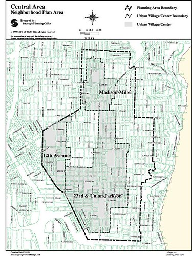
This one’s just small enough to be unreadable!
Trying to remember back to when we worked on Urban Village planning more than a decade ago, it seems to me that 12th Avenue had its own urban village, which would probably appear as a different map.
23rd Avenue had two – 23rd and Union plus 23rd S. and Jackson – that were sort of lumped together. So this map seems to combine those two, with an assumed affinity area between and around them. There was also a separate urban village at 23rd E. and Madison that is probably also on a different map.
This is all from memory. The real expert in this area is Andrew, and I hope he’ll jump in here and help us out. There are city web sites about the Comprehensive Plan that I can’t quickly find but that I’m sure exist.
You can click on the other link scott provided for a larger view: http://www.seattle.gov/DPD/planning/comprehensive/spidr/pdff
CSW is correct. Central Area neighborhood planning included four areas (or nodes) 23rd/Union, 23rd/Jackson, Madison/Miller, and 12th Avenue. The first two were later combined into one.
So-called “urban villages” come in different flavors. All of the urban village areas within the Central Area Plan, except the 12th Avenue urban village are so-called “residential urban villages”. They are not within the boundaries of what is called an “urban center”. 12th Avenue is an “urban center village” because it is within the boundaries of an “urban center”, an area expected to include more and larger places of employment. And, you’ll see on the map that the 12th Avenue urban center village, the plan for which is included in the Central Area Plan, is identified as part of the Capitol Hill Urban Center.
Perfectly clear, right?
A link to the comprehensive plan summary that provides more detail on the nature of urban villages is: http://www.seattle.gov/dpd/static/UV_element_LatestReleased_
The info on the Neighborhood Plan is at: http://www.seattle.gov/neighborhoods/npi/plans.htm
We have the Madison-Miller Residential Urban Village, the 12th Avenue Urban Village, and an Urban Center at 23rd and Jackson surrounded by the 23rd and Union-Jackson Urban Villiage
And, yes the urban villiages were sort of defined out of sync with how zoning changes have rolled out, although I am sure there were some rezones. The timing of the big Comp Plan update in 2004, and other legislation, have made our Neighborhood Plan out of whack.
As well, we never got Design Guidelines passed where other areas have done so.
DPD plans to study the situation for a years and then focus on the light rail station areas. Well, we are not waiting for DPD to study us and then tell us what our plan will be. We want to be fully prepared to engage in the planning process.
The CA Neighborhood Plan Stewardship Land Use and Open Space, and Housing Committee has launched to update those chapters of our Nieghborhood Plan. I am the co-chair. But, first we are educating ourselves so we are on solid ground when we make proposals. At our next meeting, we are going to look at the map, the overlays and the zoning. It will be the 3rd Monday in July, site TBD.
If you look at the plan chapters and decide that you have an interest in a specific area, you can help to create a committee. Contact the Steward. In the meantime, it can’t hurt to understand Land Use as that intersects with much of the rest, and should put teeth into the vision of what we want our community to be!
Online Zoning Maps:
http://www.seattle.gov/dpd/Research/Zoning_Maps/default.asp
You can also pick an address and click on the zoning detail overlay under the DPD GIS Mapping Tools:
http://www.seattle.gov/dpd/onlineservices/
General Design Guidelines:
http://www.seattle.gov/dpd/Planning/Design_Review_Program/Ap
The Other Neighborhoods’ Design Guidelines:
http://www.seattle.gov/dpd/Planning/Design_Review_Program/Ap
I ask you to educate me: what was the thinking behind the configuration of the Urban Village?
I first saw theurban village maps in Mayor Rice’s Urban Village proposals: a VERY thick 3 ring binder that I carried home from City Hall on my bike, and which is now in my basement.
As I recall, the neighbors/businesses working on the neighborhood plans had the opportunity to suggest changes to the boundaries. Everybody seemed OK with the Madison-Miller boundaries. I wasn’t at the meetings where other boundary changes might have been discussed, but don’t recall any discussions.
So, ask Norm Rice. He’s at the Evans School of Government at the U-DUB and co-hosted the neighborhood plan meeting there this Spring.